Subscribe now

Earth

Weather model shows where California will burn

10 February 2010

New Scientist. Science news and long reads from expert journalists, covering developments in science, technology, health and the environment on the website and the magazine.

Calculated risk

(Image: Sipa Press/Rex Features)

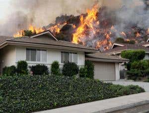
THIS year, southern California will burn – you can count on it. But we may now be able to predict which areas will be worst hit, thanks to this map. It was compiled by Max Moritz’s team at the University of California, Berkeley, and is the first to take into account fire-friendly weather.

Wild fires cause millions of dollars of damage each year in California and elsewhere. Fire researchers typically identify risk areas by looking for flammable vegetation and features like canyons that can funnel fires. There is a third factor, however, that stokes many…

Sign up to our weekly newsletter

Receive a weekly dose of discovery in your inbox. We'll also keep you up to date with New Scientist events and special offers.

Sign up

To continue reading, subscribe today with our introductory offers

Popular articles

Trending New Scientist articles

Piano Exit Overlay Banner Mobile Piano Exit Overlay Banner Desktop